About the Guide
By Keven Shevels
A 116 page full colour A5 booklet describing nine walks and the history and landscape surrounding those walks, through the length of the Teesdale valley.
The River Tees, one of the major rivers of the north and in it's upper reaches, in Teesdale, a haven for walkers. Here the main valley of the river and the side valleys of it's tributaries spread across a wide area that encompasses riverside meadows, wooded valleys, high moorland and the tall hills of the high Pennines. In short this is magnificent walking country with footpaths and terrain to suit all types of walker from those expecting a gentle riverside stroll to the long distance hill walker.
Teesdale is a stunningly beautiful valley and with it's unique and comprehensive blend of landscape, land-forms, history and heritage is a fascinating, hidden corner of England. Join the author as he travels through the secret wooded valleys and across the high hills to discover the wonders of this stirring countryside and explores both the history and the culture of it's people.
Author Biography :
Kev has been involved with outdoor sports for over forty years since his school days doing the Duke of Edinburgh award, spending his time either walking, running and latterly mountain biking through the countryside of the North East and beyond. He is not ashamed to admit that he is one of these boring people who can sit and spend hours reading a map the way that other people read a book.
His great delight is coming up with new routes that he can subsequently explore and investigate especially if he can couple this with his interest in history, in particular the prehistoric. This usually means much more than a walk as his routes tend to take a view not only on the landscape but also its relationship with events and occurrences that have happened in the past. In many ways this curiosity and knowledge of the
Durham Dales can make him a perfect guide to this under-valued part of our region.
Now in his fifties, Kev has been unable to continue his running due to injury problems but instead has been co-author of one of the most innovative series of coaching books for fell and trail runners in recent years. He now brings his easy to read, informative style of writing to guide books for those who walk in the countryside of County Durham, his home county.
Contents
Contents
Introduction
1. Introduction
2. Access & the Right to Roam
3. The Walks
4. The Weather
5. The Maps
6. Villages, Refreshments, Accommodation, Visitor Centres and Websites
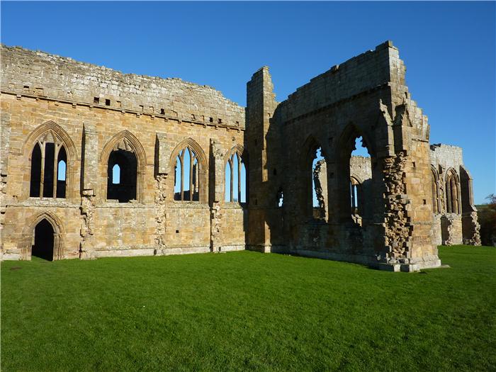
Walk 1: Eggleston Abbey and Boldron
Walk 2: Arn Gill
Walk 3: The Two Trigs of Baldersdale
Walk 4: A Teesdale Way Circular
Walk 5: Red Grooves Hush and Coldberry Gutter
Walk 6: Citron Seat and Seven Hills
Walk 7: Waterfalls and Ancient Settlements
Walk 8: Langdon Beck and Widdybank Pastures
Walk 9: Banks of the Greta and Grey Stones
Appendix
Ferguson Grading System
The Author
Walking North East
Acknowledgements
Disclaimer
The Walks
WALK 1: EGGLESTONE ABBEY AND BOLDRON
The first walk in the book traverses the countryside to the south of the River Tees, between Barnard Castle and the A66 Trans-Pennine route. Formerly part of Yorkshire before the local government reorganisation of the 1970's, this part of the dale is not often walked which is a bit of a shame really as it is an area that has it's own attractions. Along the way you'll pass the ruins of the most northern of the monastic houses of Yorkshire. Although a lesser cousin of the great abbeys of Rievaulx, Jervaulx and Fountains, the remains of Egglestone Abbey are still quite spectacular albeit on a smaller scale. From the abbey the route makes it's way up to the small village of Boldron, a village that through it's old well, may have a link to one of the greatest kings of England, Athelstan, grandson of Alfred the Great and the first king to unite all of the country that became England and indeed, the first king to have dominance over the whole of the British Isles.
DISTANCE: 5.4 miles / 8.6 km.
ASCENT: 574 feet / 175 metres.
TERRAIN: Mainly field paths and tracks with a couple of short stretches of road walking along quiet country lanes. Although there is some climbing on this walk there is nothing that can be considered significant.
TIME: 3½ to 4 hours.
START: The Butter Market in Barnard Castle. GR NZ 050 163. There is ample parking within Barnard Castle that gives access to the Butter Market.
MAP: OL31:North Pennines. Teesdale and Weardale.
ACCESS: The route is all on public rights of way.
DOGS: As the route is all on public rights of way then dogs are allowed. However, be aware that the route does go through the middle of a caravan park and that you will also encounter both sheep and cattle throughout this route so please keep your dog under close control preferably on a lead.
FGS GRADING
Grading is T4 [ D0, N1, T1, R1, H1]
WALK 2: ARN GILL.
To the north of Teesdale lie a number of small springs and streams that form hanging valleys that run above the northern slopes of the main dale. Some of these watercourses run down to join the Tees while others join to form the River Gaunless which runs north-east to ultimately join the River Wear
This is an area that is not often walked, which is a bit of a shame really as it is a part of Teesdale that is full of surprises not least the fact that it is more closely associated with the coal mines of central Durham rather than the lead mines of the upper dale.
DISTANCE: 7.1 miles / 11.3 km.
ASCENT: 833 feet / 254 metres.
TERRAIN: The majority of this walk is on field paths over pasture land, however, some of this is rough pasture with an uneven surface that will probably have been churned up by livestock. At the beginning and the end of the walk, the route follows tracks through woodland. There is one short, steep climb as you come out of Arn Gill.
TIME: 4½ to 5 hours.
START: Small road-side car park at the Copley Smelt Mill which lies on the Barnard Castle - Copley and Woodland road. GR NZ 086 250.
MAP: OL31. North Pennines. Teesdale and Weardale.
ACCESS: The route is all on public rights of way.
DOGS: As the route is all on rights of way then dogs are allowed, however, please keep them under close control, preferably on a lead. The majority of the walk crosses pasture land and so livestock will be encountered in most of the fields. During spring many of the fields do contain young lambs. There are a number of high stiles that your dog may need to be lifted over.
FGS GRADING
Grading is T5 [ D1, N1, T1, R1, H1]
WALK 3: THE TWO TRIGS OF BALDERSDALE
The River Balder is one of the main tributaries of the upland River Tees and together with the Lune, forms what is known as Teesdale's Lakeland due to the number of reservoirs contained within these two small valleys. On the south side of Baldersdale lie a range of low hills that sweep down into Sled Dale and, ultimately, to Stainmore itself.
This walk explores the open moorland on this side of the dale and takes in the two trig points that line this side of the valley. This is a walk of far horizons, as the advertising blurb would say. Despite their relatively low height, these hills give wide ranging views deep into the Pennines and across to the other side of Teesdale. Here you can, quite truthfully, feel as if you were walking across the top of the world.
DISTANCE: 8.8 miles / 14.1 km.
ASCENT: 712 feet / 217 metres.
TERRAIN: Most of this walk is over pathless open moor. This involves rough ground and in many places this also means wet and boggy. On the return leg you follow a moorland track down Race Yate Rigg but it is only in the final stretches from Battle Hill Farm that this becomes dry and solid. There is a short road section on this walk. Although there is a fair amount of climbing there is nothing that is particularly steep, it is more long and gradual.
TIME: 4¼ to 4¾ hours.
START: Car parking space at the end of the minor road that leads to Booze Wood Farm. GR NY 987 189.
MAP: OL31. North Pennines. Teesdale and Weardale.
ACCESS: This route uses a combination of public rights of way and open access land with most of the open moor walking being on the open access land. Even when rights of way are used to cross the moor, these rarely exist on the ground and are easily lost.
DOGS: Not allowed on the access land.
FGS GRADING
Grading is F6 [ D1, N1, T2, R2, H0]
WALK 4: A TEESDALE WAY CIRCULAR
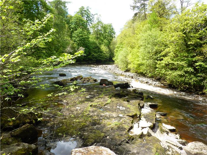
The Teesdale Way makes it's way from Dufton in Cumbria, across the Pennines and then follows the course of the River Tees downstream until it empties it's waters into the North Sea at Teesmouth. In many places the path makes it's way down both sides of the river at the same time and this walk utilises one of these sections to make a circular walk on either side of the river between Egglestone and Cotherstone and along the way discovers some hidden histories of the old dale..
DISTANCE: 5.4 miles / 8.7 km
ASCENT: 545 feet / 166 metres
TERRAIN: The bulk of this walk comprises field and meadow walking with a couple of short woodland paths. However, there is one section, as the path follows the Tees upstream, where the path is very rocky and in places skirts the water's edge. Here the path does undulate up and down the side of the bank and in places has been eroded by rain and floods. Because of the path's proximity to the river on this stretch then this walk should not be attempted in bad weather or at times of high water levels. There is no significant climbing on this route although there may be sections, when the path goes through woods and next to the river, where there may be short but steep climbs.
TIME: 4 to 4½ hours.
START: The village green in Romaldkirk. GR NY 994 220.
MAP: OL31. North Pennines. Teesdale and Weardale.
ACCESS: The route is all on public rights of way.
DOGS: As the route is all on public rights of way then dogs are allowed but as the majority of the route is through grazing meadows then you will encounter sheep and other livestock and so it is advisable to keep your dog on a lead. There are a number of tall stiles to lift your dog over and one section as the path runs next to the river will be a bit rocky underfoot for your pet. If you decide to visit the viewpoint of Percy Myres Rock then your dog will definitely need to be on a lead.
FGS GRADING
Grading is T4 [ D0, N1, T1, R1, H1]
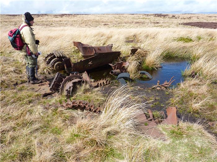
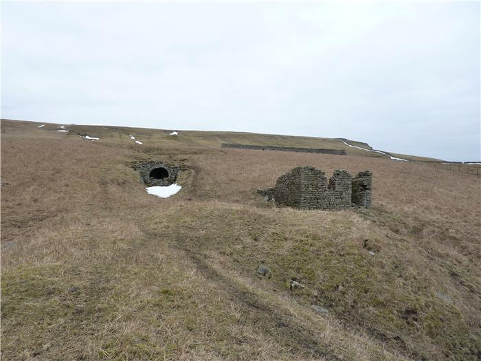
WALK 5: RED GROOVES HUSH AND COLDBERRY GUTTER
Just north of Middleton-in-Teesdale lies the small side-valley of the Hudeshope Beck. During the 18th and 19th centuries this little dead-end valley was a hive of industrial activity as men from Middleton and the surrounding area toiled both above and below ground wresting lead ore from the rocks of this valley.
DISTANCE: 6.9 mile / 11.1 km.
ASCENT: 968 feet / 295 metres.
TERRAIN: The first section of this walk is a rather lengthy road walk of nearly three miles after which a moorland track is followed to get to the bottom of Red Grooves Hush. From there, walking up the hush and down Coldberry Gutter is the equivalent of walking over the open moor and well within the capability of the average hill walker. After Coldberry Shop, field paths and a quiet country road are followed back to Middleton. The climbing in this walk is more long and steady rather than short and steep.
TIME: 4½ hours
START: Middleton-in-Teesdale market place. GR NY 947 254.
MAP: OL31. North Pennines. Teesdale and Weardale.
ACCESS: Most of the route is on public rights of way, however, the middle, linking section that goes over Red Grooves Hush and Coldberry Gutter is on access land.
DOGS: Not allowed on the access land.
FGS GRADING
Grading is F6 [ D1, N1, T1, R1, H2]
WALK 6: CITRON SEAT AND SEVEN HILLS
Carved by the Stainmore Glacier during the last Ice Age, the Stainmore Gap is a relatively low-level pass between the higher hills of the Pennines lying to the north and south. For thousands of years man has used this pass to travel from one side of this mountain range to the other. Situated on the eastern side of this pass, the small village of Bowes has long been the guardian of the eastern entrance. The remains of two forts, Roman and Norman, provide testimony to it's strategic importance.
This walk explores the low hills to the south of the village, an area that is not that often visited by the walker. Here the hills may be low but they provide extensive views through the Gap itself and to the higher hills both north and south. The walk also takes the opportunity to visit the long-forgotten lead mine of the Eller Beck.
DISTANCE: 7.4 mile / 11.8 km
ASCENT: 1,161 feet / 354 metres
TERRAIN: The majority of this walk is over moorland paths some of which are quite boggy irrespective of which time of year you walk this route and some which have the habit of appearing and disappearing amongst the heather and reeds. At times you may wonder if you are actually following a path at all. There are no particularly steep climbs on this walk, they tend to be more long and steady.
TIME: 4½ hours
START: Bowes and Gilmonby Village Hall car park. GR NY 996 135.
MAP: OL31 North Pennines. Teesdale and Weardale.
ACCESS: The route is a mixture of public rights of way and open access land. Although most of the route over the moor is on rights of way, the descent down to Eller Beck Mine and the descent down off the moor after Citron Seat are over open access land.
DOGS: Not allowed on the access land.
FGS GRADING
Grading is F8 [ D1, N1, T2, R2, H2]
WALK 7: WATERFALLS AND ANCIENT SETTLEMENTS
Teesdale is noted for it's waterfalls with the surging waters of the Tees boiling over rocky outcrops as it makes it's way downstream. Indeed, this is where the name Tees comes from, from the ancient Celtic and relates to the Welsh ‘Tes' with the meaning ‘boiling, surging river'. Here many of these torrents bear the name ‘force', a remnant from the days when the Vikings settled this region, ‘fors' being Old Norse for waterfall. As you can tell from the history of the names within the dale, this valley has a long past much of which goes unnoticed unless you know what to look for. This walk mixes both waterfalls and the remains of ancient settlements that span the long history of man's occupation of this dale.
DISTANCE: 7.8 miles / 12.5 km.
ASCENT: 778 feet / 237 metres.
TERRAIN: Initially the route follows a field track to Dirt Pit before going over a couple of field paths to the roadside and then following the roadside pavement for a short distance. Paths over rough pasture are then followed to a bridge crossing of the River Tees and then the Pennine Way is followed alongside the river back to the Wynch Bridge and a crossing of the river back to Bowlees. The Pennine Way is a mixture of open moorland, rough pasture and riverside paths but despite being well-walked can be a bit soft and boggy in places. There is one short but steep climb up through the crags after passing Cronkley Farm but all the other climbs are more gradual and not that significant.
TIME: 4 to 4½ hours.
START: Bowlees Car Park. GR NY 907 283.
MAP: This route is on OL31 North Pennines although it is split over both sides of the map.
ACCESS: The route is all on public rights of way.
DOGS: As the route is all on rights of way then dogs are allowed but keep them under close control, preferably on a leash. Livestock, especially sheep, will be encountered throughout the walk plus you will also go through or pass farmyards where other dogs will probably be encountered. There are a number of stiles on the walk that may require you to lift your dog over.
FGS Grading
Grading is F6 [ D1, N1, T2, R1, H1]
WALK 8: LANGDON BECK & WIDDYBANK PASTURES
A walk into the wide open spaces of the upper dale and one that when walked in the winter months can really demonstrate the open, wild aspects of the upper reaches of this valley. Along the way you'll come across what is called a multi-period ancient monument, an earthwork that was used through a number of time periods. You'll also come across a little known lead mine and, hopefully, you'll not have an encounter with a fearsome water hag.
DISTANCE: 6.8 mile / 10.9 km
ASCENT: 541 feet / 165 metres
TERRAIN: The walk does tend to split about 50/50 over walking on track and walking over rough pasture. In and after periods of wet weather there are patches where the pasture can get wet underfoot but by following the guide and using common sense, then you can normally miss the worst of these. The majority of the climbing on this route is in the early stages when you are heading up from the car park and is more of a steady climb than steep.
TIME: 4 to 4½ hours
START: Hanging Shaw car park. GR NY 867 298.
MAP: OL31 North Pennines. Teesdale and Weardale.
ACCESS: The route is all on public rights of way.
DOGS: As the route is all on public rights of way, then dogs are allowed. However, as this route crosses Moor House National Nature Reserve then they must be kept on a lead at all times. Livestock, including sheep, cattle and horses will be encountered throughout the route and in addition, as the route does pass through a couple of farmyards, then farm dogs will also probably be encountered. There are also quite a number of high stiles on this walk that will require you to lift your dog over.
FGS Grading
Grading is F4 [ D1, N1, T1, R1, H0]
WALK 9: BANKS OF THE GRETA AND GREY STONES
Teesdale was described by Wainwright in his book on the Pennine Way as 'sylvan' mainly due to the trees lining the river on it's journey upstream from Middleton. However, there are small parts of Teesdale where the ancient woodland that once cloaked the entire country still exists. As in most parts these woods survive in the steep-sided valleys of rivers and streams where the land couldn't be put to a more productive use and has, in the main, just been left.
This walk follows one of these stretches of woodland, this one lining the side of the River Greta, a tributary of the Tees. Although not necessarily an easy walk, this stretch along the banks of the Greta rewards the effort by being one of the best woodland walks in the county and definitely gives a sense of exploring the ancient wild wood of folklore. As you leave the woodland, you'll pass the remains of a small medieval castle that was the centre of the settlements along the Greta during the Middle Ages. Later in the walk, evidence of another settlement is uncovered, this one going further back in time to before the arrival of the upstarts from Italy, the Romans, on these shores.
DISTANCE: 6.6 mile / 10.6 km
ASCENT: 650 feet / 198 metres
TERRAIN: In the main, this walk encompasses field and woodland paths with a stretch along a very quiet country lane. However, the woods in question border the edge of the steep-sided Greta valley and in a number of places go down to the riverside and then come back up again. Some of these climbs and descents, although not long, are quite steep and in places there is a bit of exposure, a steep drop down into the valley on one side of the path. There are also two stream crossings on this walk both of which do not use a bridge. In times of bad weather or high water levels it would be advisable not to do this walk.
TIME: 4½ to 5 hours
START: The village of Barningham. There is a long green on one side of the road as you pass through the village and there is ample road-side parking either next to the green or outside the houses on the opposite side of the road. However, please don't park on the green itself or inconvenience local residents. GR GR NZ 084 103.
MAP: OL30 Yorkshire Dales - Northern and Central Areas.
ACCESS: The route is all on public rights of way apart from a short diversion over access land to visit the prehistoric settlement of Grey Stones.
DOGS: As the route is all public rights of way, then dogs are allowed. However, be aware that there are sections of this walk, as it goes through the woods bordering the River Greta, that have a steep drop to one side down to the river. In addition, you are quite likely to meet cattle, including a bull, in the fields surrounding Scargill Farm.
FGS Grading
Grading is T5 [ D1, N1, T2, R1, H0]